St. Croix Island seen from the nearest landfall at Hougham Park, just east of the Coega harbour development. From here the island is about 4 km to sea. Two disused stone bungalows, used by guano collectors and then by the University of Port Elizabeth for research purposes are visible.
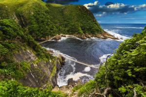
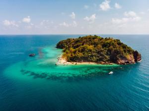
St. Croix Island at 33°47′58″S 25°46′11″E is 3.9 km (2.4 mi) from the nearest land and rises to 59 m (194 ft). The BirdLife fact sheet states the 12 ha (30 acres) island is only 58 m (190 ft) above sea level. It adds that the island is rocky and “supports minimal vegetation”. The island runs 700 m (2,300 ft) along a northwest, southeast axis and is about 360 m (1,180 ft) wide at its broadest – along the west coast. Its highest point is halfway along the north coast. Bartholomeu Dias planted a padrão and celebrated Mass on the island in March 1488.
St. Croix Island at 33°47′58″S 25°46′11″E is 3.9 km (2.4 mi) from the nearest land and rises to 59 m (194 ft). The BirdLife fact sheet states the 12 ha (30 acres) island is only 58 m (190 ft) above sea level. It adds that the island is rocky and “supports minimal vegetation”. The island runs 700 m (2,300 ft) along a northwest, southeast axis and is about 360 m (1,180 ft) wide at its broadest – along the west coast. Its highest point is halfway along the north coast. Bartholomeu Dias planted a padrão and celebrated Mass on the island in March 1488.